Riga Waterfront
Scroll to explore

Overview
Reconnecting Riga with the Daugava through a vibrant mixed-use waterfront district rooted in its industrial heritage.
Details
Industry
Urban Design
Date Completed
2025
Team
Dagnija Smilga, Beatrise Steina, Annija Lausa, Lauma Auziņa, Sandis Radziņš, Camila Yakubova, Marvin van Koll, Andis Dzenis, Ömer Gürel, Kristiāna Erta, Artūrs Tols
Collaboration
Hosoya Schaefer Architects AG, Gillespies, Samra Norde Architects, Projects3, Faulknerbrowns Architects, E.Daniševskis birojs, Solvers, Royal HaskoningDHV
Location
Riga, Latvia
Commission
Commission
Client
Riga Waterfront, Eagle Hills

City context
Andrejsala is located within the protection zone of the UNESCO World Heritage Site – the Historic Centre of Riga, on the banks of the Daugava River, away from the Old Town. Since the Soviet occupation, it has remained a degraded industrial port area, with only a limited number of individual cultural and historical buildings. At present, Riga’s urban area remains disconnected from its waterfront.
The development vision provides for transforming the area from a closed and degraded area into a publicly accessible one, preserving all identified cultural, historical and natural values, ensuring accessibility to the waterfront.
Concept
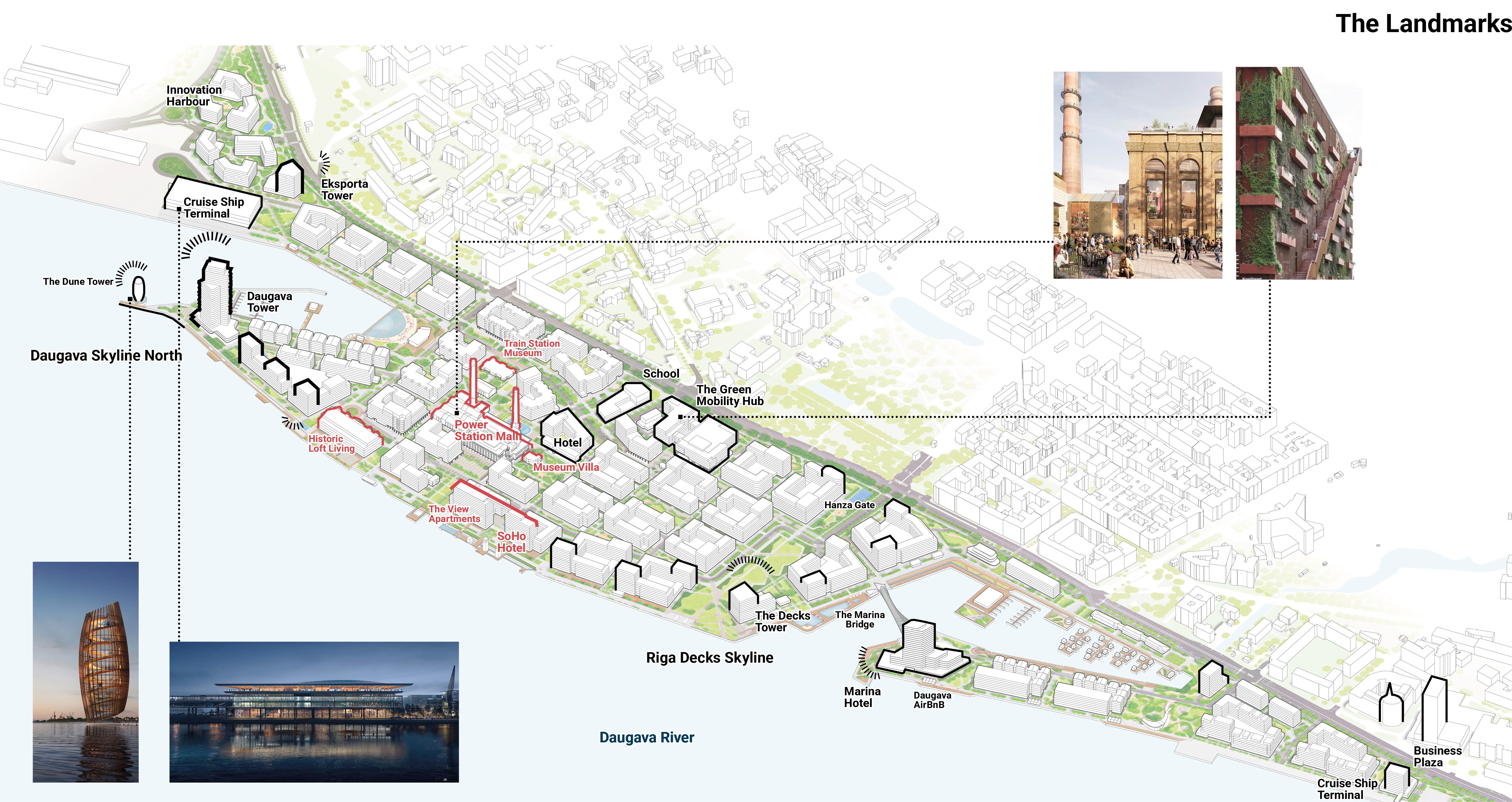
Riga Waterfront is envisioned as a vibrant mixed-use district with a predominantly residential use (71,5%), integrating commerce, culture, and leisure within a unique waterfront setting. At the heart of the development, the Riga Power Station will become a unique retail and food destination, combining artisan eateries, boutique shops, and lively social spaces. Six complementary districts, linked by a shared public realm, integrated mobility, and a continuous waterfront, create a cohesive urban ecosystem designed for residents, workers, students, and visitors. Convenient connections to the city centre, including a tram line and an expanded ferry terminal, ensure the development remains closely integrated with the wider city.

Industrial Heritage
The Masterplan respects and celebrates Riga’s industrial heritage by preserving valuable buildings and infrastructure elements, adapting them for reuse and integrating them into the public realm. The Power Station forms a key focal point, transformed into a retail, leisure and cultural destination, with its chimneys preserved as landmarks. The former railway station is reimagined as a cultural venue, while the silos are adapted for residential use.
Urban Structure
The urban structure is conceived as a sequence of distinctive spaces rather than rigid linear axes, prioritising pedestrian movement and creating a human-scale environment. Building heights respond to the surrounding streetscapes, varying according to orientation and context. This creates a dynamic composition and diverse skyline, while maintaining a more intimate scale within the central areas. Height distribution respects key view corridors, with taller accents concentrated along the waterfront and carefully positioned to create landmark moments and defined urban spaces.
Street Network
The street network for cars consists mainly of two loops of local streets, completed by neighborhood streets to close the network. Most streets are pedestrian-only to make walking and cycling attractive and create calm, children-friendly public spaces. The boulevard functions as a regular street outside peak shopping hours, while becoming traffic-free during shopping hours and on Saturdays.
Open Space
A network of squares, parks, boulevards and promenades creates a cohesive public realm, connecting key destinations and the district to the Daugava. Green “windows” open towards the waterfront, while parks, tree-lined streets and semi-private courtyards extend greenery throughout the neighbourhood. Andrejosta Park connects Eksporta Street, the Masterplan development and the waterfront. Existing valuable trees, including the Eksporta Street tree alley, are preserved and integrated into the landscape. A continuous waterfront pathway connects the Old Town at Vanšu Bridge to the planned terminal, with steps, wooden decks, pools and landscaped terraces bringing people directly to the water.
Neighbourhoods
The site is divided into distinct neighbourhoods, each with its own character, mix of uses and open spaces. Eksporta Basin, Riga SoHo, Port City Courtyards, Riga Decks, Riga Marina and Innovation Harbour each have distinct building typologies, public spaces and waterfront activities, responding to their context while preserving and integrating the area’s industrial heritage.